


 2 / 2
2 / 2
THEMED TRAILS
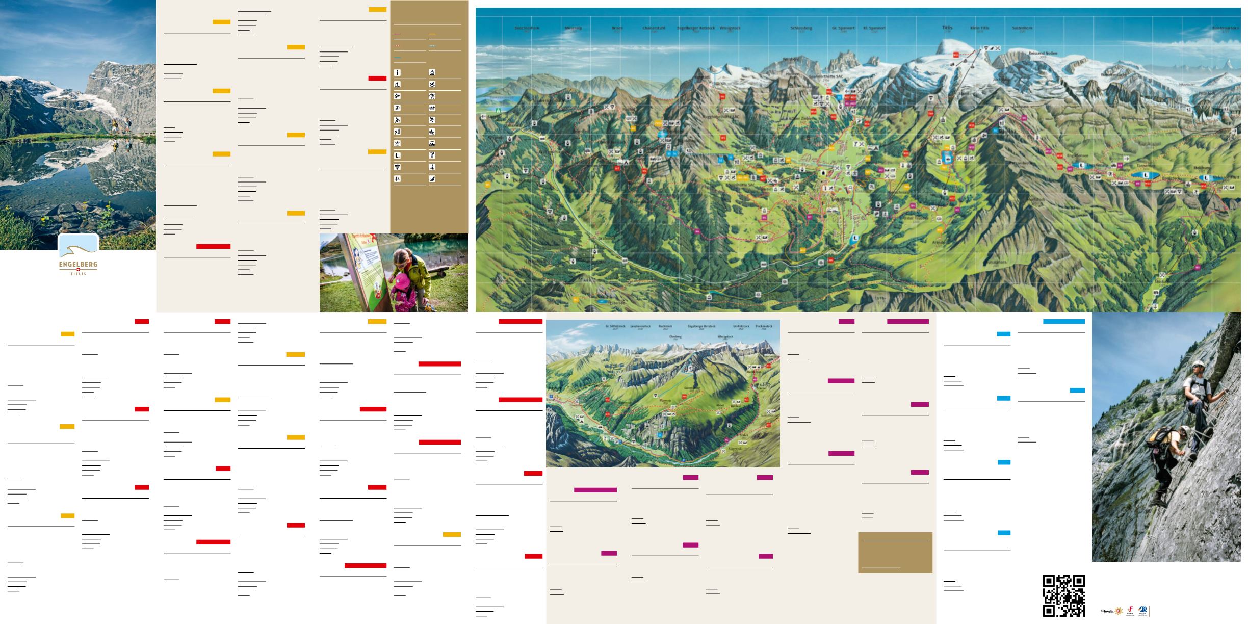
BRUNNI
TW1 | F10
KITZEL TRAIL
Walk barefoot around Lake Härzlisee and
experience the sensation of various tex-
tures underfoot, such as sand, clay,
water and pebbles, improve circulation
in your feet.
CIRCULAR ROUTE
from the mountain
station Brunni-Chairlift
DISTANCE
220 metres
ALTITUDE
1860 metres
BRUNNI
TW2 | F10
HEILKRÄUTER TRAILS
Discover more about the application and
benefits of Alpine plants on the Heilkräu-
ter Trails between Lake Härzlisee and the
Brunni Lodge.
START
mountain station Brunni-Chairlift
DISTANCE
700 metres
ALTITUDE
1860 metres
LEVEL
easy (hiking trail)
BRUNNI
TW3 | F10
BRUNNI TRAIL
Discover more about mountain wildlife
by studying the twelve large information
boards placed along this trail. There are
also small signs along the footpath
describing the Alpine flowers and plants,
as well as wooden sculptures carved for
the Artifex Montanaus project.
CIRCULAR ROUTE
Ristis – Rosenbold –
Mountain Lodge – Holzstein – Rigidal-
stafel – Ristis
WALKING TIME
2 to 2½hours
DISTANCE
5,8 kilometres
ALTITUDE
1610 to 1860 metres
LEVEL
easy (hiking trail)
FÜRENALP
TW4 | Fürenalp map
GROTZLI TRAIL
‘Grotzli’ is the local dialect word for a
young fir tree in the Engelberg dialect.
This circular hiking trail leads through
forests and meadows up on to Fürenalp,
with plenty of places along the way to
rest and enjoy the view.
RISTIS
W4 | F6
WALEN TRAIL
Experience a spectacular, high-Alpine hike
with incredible views. This trail is only
recommended for the sure-footed.
COURSE
Engelberg – Ristis (cableway) –
Hüttismatt – Alp Rosenbold or SAC
Brunni Mountain Hut – Alp Rosenbold –
Walenalp – Walegg – Alp Oberfeld –
Urnerstafel – Chrüzhütte – Oberrrickenbach
WALKING TIME
3½hours
DISTANCE
11 kilometres
ALTITUDE
1600 to 890 metres
LEVEL
difficult (mountain hiking trail)
SEASON
June to September
RISTIS
W5 | E9
RUGGHUBEL TRAIL
A mountain hike for those who enjoy the
good life – take the cableway to Ristis
and then continue on foot to the SAC
Rugghubel mountain lodge for a tasty
meal before heading back.
COURSE
Engelberg – Ristis (cableway) –
Rigidalstafel – Rugghubel
WALKING TIME
3 hours
DISTANCE
8,5 kilometres
ALTITUDE
1860 to 2300 metres
LEVEL
medium (mountain hiking trail)
ENGELBERG
W6 | C9
ROT GRÄTLI
Over the Karrenflächen at the foot of the
Rohstock directly to Rot Grätli. Sure-footed-
ness required.
COURSE
Engelberg – Ristis – Rugghubel-
hütte – Rot Grätli – Bannalper Schonegg –
Chrüzhütte – Oberrickenbach
WALKING TIME
5 to 7 hours
DISTANCE
14 kilometres
ALTITUDE
1600 to 2600 metres
LEVEL
difficult (mountain hiking trail)
HIKING TRAILS
ENGELBERGERTAL
W1 | J4
ZINGEL HIKE (RUGISBALM)
The trail begins from Eggen mountain
station and leads to the Lutersee lake,
lying at an altitude of roughly 300metres.
In good weather, you can see the TITLIS
reflected in this idyllic mountain lake. From
here you descend via Zingel and Arni to
Engelberg.
COURSE
Mettlen-Rugisbalm-Eggen (Luft-
seilbahn) – Lutersee – Ober Teil – Zingel –
Arni Untertrübsee – Engelberg
WALKING TIME
3 hours
DISTANCE
6,6 kilometres
ALTITUDE
1750 to 1050metres
LEVEL
medium to difficult
ENGELBERGERTAL
W2 | D6
THE HALDIGRAT
ZIGZAGTRAIL
From Oberrickenbach/Fell the trail begins
with a steep climb up to Sinsgäu-Widderen.
Here you can pause to catch your breath
before setting off on the new zigzag path
up to Haldigrat. Tip: Use the Fell-Chrüzhütte
cableway for a slightly less strenuous hike.
COURSE
Oberrickenbach – Spiess –
Widderen – Zickzackweg – Haldigrat
WALKING TIME
3 hours 50minutes
DISTANCE
6,5 kilometres
ALTITUDE
903 to 2090metres
LEVEL
medium to difficult
ENGELBERGERTAL
W3 | F1
THE OBERALP HIKE
Take the cableway to Diegisbalm or a little
further to Oberalp. From here, the path
sets off via Lochhütte, Egg and Schellenflu-
ehütte until it reaches Chälenhütte. You
then descend via Dossen, Zingeli and Böd-
men to the cableway station at Büelen.
COURSE
Wolfenschiessen – Oberalp –
Lochhütte – Egg – Chälenhütte –
Zingeli – Bödmen – Büelen
WALKING TIME
3 hours 50minutes
DISTANCE
10 kilometres
ALTITUDE
1112 to 1737metres
LEVEL
medium to difficult
ENGELBERG
W7 | F10
BENEDICTINE WAY
This path was originally created to con-
nect two abbeys, and offers magnificent
views from the ridge at Rosenbold.
COURSE
Engelberg – Kloster –
Flühmatt – Ristis – Rosenbold –
Walenpfad – Egglirat – Oberrickenbach –
Mittlist Hüttli – Niederrickenbach
WALKING TIME
7½hours
DISTANCE
20 kilometres
ALTITUDE
1000 to 1860 metres
LEVEL
difficult (mountain hiking trail)
ENGELBERG
W8 | E11
GROTTEN TRAIL
This perfect hike for families leads from
Engelberg to the valley basin behind
Hinter Horbis.
COURSE
Engelberg – Kloster – Buechli –
Grottenweg – Horbis – End der Welt
WALKING TIME
1 hour
DISTANCE
2,5 kilometres
ALTITUDE
1000 to 1130 metres
LEVEL
easy (hiking trail)
ENGELBERG
W9 | I13
AA GORGE ADVENTURE TRAIL
Experience this spectacular trail through
the rugged Aa Gorge. After crossing the
ninth bridge; the path then levels out as
it continues on to Grafenort.
COURSE
Engelberg – Eugenisee –
Aaschlucht – Obermatt – Grafenort
WALKING TIME
2¼hours
DISTANCE
7,2 kilometres
ALTITUDE
1000 to 570 metres
LEVEL
medium
ENGELBERG
W10 | E20, F23, F25
FOUR LAKES HIKE
Take a wonderful hike to Melchsee-Frutt –
you can even travel certain parts by
cableway. The return journey to Engel-
berg is by public transport.
COURSE
Engelberg – Gerschnialp –
Trübsee – Jochpass – Engstlenalp –
Tannalp – Chringen – Bettenalp –
Melchsee-Frutt
Alternative from Chringen: Bonistock –
Karstfelder – Melchsee-Frutt – Stöckalp
(add 1 hour)
WALKING TIME
7 hours
DISTANCE
21 kilometres
ALTITUDE
1000 to 2220 metres
LEVEL
medium (mountain hiking trail)
SEASON
June to September
ENGELBERG
W11 | H12
BERGLI TRAIL
This beautiful hike winds through forests
to the picturesque Schwand Chapel, with
a perfect spot for a picnic at the Spis-
boden crossroads. Walk back via either
Bergli or Flühmatt.
CIRCULAR ROUTE
Engelberg – Hotel
Waldegg – Schwand – Spisboden – Bergli
or Flühmatt – Engelberg
WALKING TIME
2½hours
DISTANCE
9 kilometres
ALTITUDE
1050 to 1300 metres
LEVEL
easy (hiking trail)
ENGELBERG
W12 | E14
RIVER AA TRAIL
This pleasant hike begins in the valley at
scenic Lake Eugenisee, just as you enter
the village of Engelberg. Taking the Pro-
fessorenweg path along the Engelberg Aa
river, you will reach Eienwäldli camp-
ground. Continue alongthe riverside
path. It will lead youto the waterfall.
COURSE
Engelberg – Eienwäldli –
Wasserfall (Waterfall)
WALKING TIME
1 hour
DISTANCE
4 kilometres
ALTITUDE
1000 to 1070 metres
LEVEL
easy (hiking trail)
ENGELBERG
W13 | G17
TRÜBSEE HIKE
This trail leads through forests and
meadows to Untertrübsee, from where
you can either continue on foot or take
the cableway to Obertrübsee. You then
join the Alpine Flora Trail to reach Trüb-
see station.
COURSE
Engelberg – Untertrübsee –
Obertrübsee – Station Trübsee
WALKING TIME
3 hours
DISTANCE
7,5 kilometres
ALTITUDE
1050 to 1800 metres
LEVEL
medium (mountain hiking trail)
ENGELBERG
W14 | H16
ARNIWANG
After an uphill hike through the Gerschni-
wald forest, the path then crosses flowery
Alpine meadows to the Arnialp. The route
home passes over the Schwändli and back
to Engelberg.
CIRCULAR ROUTE
Engelberg – Unter-
trübsee – Arni – Haltenhütte – Staldeli –
Staldirain – Schwändli – Äschboden –
Engelberg
WALKING TIME
4½hours
DISTANCE
14,5 kilometres
ALTITUDE
1050 to 1350 metres
LEVEL
medium (hiking trail)
ENGELBERG
W15 | E15, D17
PFAFFENWAND JOCHPASS
This is a steep trail from Engelberg via
Pfaffenwand to Lake Trübsee and then
on to Jochpass. The journey back is via
cableway.
COURSE
Engelberg – Bänklialpweg –
Gerschnialp – Pfaffenwand – Trübsee –
Jochpass
WALKING TIME
4 hours
DISTANCE
10 kilometres
ALTITUDE
1050 to 2200 metres
LEVEL
difficult (mountain hiking trail)
ENGELBERG
W16 | D14
HOHFAD TRAIL
Take a demanding hike over Hohfad to
Herrenrüti, then across the valley back to
Engelberg.
CIRCULAR ROUTE
Engelberg –
Eienwäldli – Vordrist Eien – Hohfad –
Bödmen – Firnalpeli – Herrenrüti –
Eienwäldli – Engelberg
WALKING TIME
4½hours
DISTANCE
14 kilometres
ALTITUDE
1050 to 1380 metres
LEVEL
difficult (mountain hiking trail)
ENGELBERG
W17 | C13 & Fürenalp map
SPANNORT LODGE
Hike through the lush green Engelberg
Valley to Alpenrösli. From here the route
ascends steeply to the Spannort Lodge,
where your efforts are rewarded with an
impressive view.
COURSE
Engelberg – Wasserfall –
Herrenrüti – Alpenrösli – Stäfeli –
Spannorthütte SAC
WALKING TIME
4½hours
DISTANCE
11 kilometres
ALTITUDE
1800 to 2000 metres
LEVEL
difficult (mountain hiking trail)
ENGELBERG
W18 | D12 & Fürenalp map
FÜRENALP HIGH-ALPINE HIKE
Reach new heights on this high-Alpine
hike along the Hahnen to Fürenalp.
CIRCULAR ROUTE
Engelberg – Buechli –
Horbis – End der Welt – Zieblen – Dagen-
stal – Fürenalp – Stäuber – Stäfeli –
Alpenrösli – Herrenrüti – Wasserfall –
Engelberg
WALKING TIME
7 hours
DISTANCE
23 kilometres
ALTITUDE
1050 to 1840 metres
LEVEL
difficult (mountain hiking trail)
ENGELBERG
W19 | C13 & Fürenalp map
SURENEN PASS
Take it to the limit on this hike – or at
least to the border of the canton! You
can enjoy boundless views on this
demanding day trek.
COURSE
Engelberg – Wasserfall –
Herrenrüti – Alpenrösli – Stäfeli –
Stäuber – return or go on to
Blackenalp – Surenenpass – Eifrutt –
Waldnacht – Scheidweg – Hofstätten –
Attinghausen
WALKING TIME
1 day
DISTANCE
22 kilometres
ALTITUDE
1050 to 2300 metres
LEVEL
difficult (mountain hiking trail)
ENGELBERG
W20 | E13
CHAPEL TRAIL
Enjoy a gentle hike from Engelberg to the
Maria im Holz Chapel, then onwards to
Wasserfall.
COURSE
Engelberg – Klostermatte –
Schweizerhausstrasse – Kapelle –
Wasserfall
WALKING TIME
1 hour
DISTANCE
4,5 kilometres
ALTITUDE
1050 to 1070 metres
LEVEL
easy (hiking trail)
FÜRENALP
W21 | C13 & Fürenalp map
FÜRENALP PANORAMA HIKE
Travel by cableway to Fürenalp, then cross
flowering Alpine meadows on foot to the
Äbnet alp. You can also make your descent
taking the Äbnet – Stäfeli cableway.
COURSE
Fürenalp – Äbnet –
Stäuber – Stäfeli – Alpenrösli –
Herrenrüti – Wasserfall – Engelberg
WALKING TIME
4 hours
DISTANCE
10 kilometres
ALTITUDE
1850 to 1050 metres
LEVEL
medium (mountain hiking trail)
FÜRENALP
W22 | D13 & Fürenalp map
WASSERFALL
Set off from the mountain station on a
steep and demanding hike down into the
valley through open woodland. Stop to
enjoy the view from Dagenstal on the way.
COURSE
Fürenalp – Dagenstal –
Wasserfall – Fürenalp valley station
WALKING TIME
1½hours
DISTANCE
4,5 kilometres
ALTITUDE
1850 to 1050 metres
LEVEL
difficult (mountain hiking trail)
TRÜBSEE
W23 | F20
MARMOT HIKE
Go on an Alpine safari! This hike will
bring you face to face with the region’s
delightful little marmots – and with a bit
of luck you might just spot ibex and
chamois too.
CIRCULAR ROUTE
Trübsee – Jochpass
(chairlift) – Schaftal – Tannalp –
Engstlenalp – Jochpass – Trübsee
WALKING TIME
5 hours
DISTANCE
15 kilometres
ALTITUDE
1800 to 2220 metres
LEVEL
medium (mountain hiking trail)
TITLIS
W24 | B17
STOTZIG EGG GLACIER TRAIL
Experience eternal winter up on the TITLIS
glacier while hiking from the mountain
station to Stotzig Egg viewpoint. There
you’ll have a panoramic view overlooking
almost all of Switzerland.
COURSE
TITLIS mountain station –
Stotzig Egg
WALKING TIME
1 hour
ALTITUDE
3020 metres
LEVEL
easy (glacier hiking trail)
MOUNTAIN BIKING
ENGELBERG
M1 | C13 & Fürenalp map
STÄFELI*
Ascent of medium difficulty on a tarred
road, followed by a natural path to the
Alpenrösli and a difficult mountain road
with some steep sections.
LEVEL
easy
TRAIL 1
Engelberg – Wasserfall –
Herrenrüti – Alpenrösli – Stäfeli – back
450 metres
18 kilometres
ENGELBERG
M2 | F14
TRAUBODEN*
From Engelberg to Trauboden through
the shady Gerschniwald forest; ascent of
medium difficulty mostly on natural
paths.
LEVEL
easy
TRAIL 3
Engelberg – Gerschnialp
mountain station – Restaurant Ritz –
Trauboden – back
320 metres
14 kilometres
ENGELBERG
M3 | G17
TRÜBSEE
From Engelberg to Lake Trübsee along
forest roads and woodland paths; a chal-
lenging trail for ambitious cyclist with
the option to take a cableway from
Untertrübsee to Obertrübsee.
LEVEL
difficult
TRAIL 4
Engelberg – Untertrübsee –
Obertrübsee – back
830 metres
13 kilometres
ENGELBERG
M4 | G15
ARNIALP*
Ascent of medium difficulty on natural
paths through shady woods to Unter
trübsee, then on to Arnialp.
LEVEL
easy
TRAIL 6
Engelberg – Untertrübsee –
Arnialp – back
330 metres
16 kilometres
ENGELBERG
M5 | G10
SAC BRUNNI
MOUNTAIN HUT*
A trail for ambitious cyclists: enjoy a
quick break and perhaps a picnic
at Spisboden before tackling the most
challenging stage.
LEVEL
difficult
TRAIL 7
Engelberg – Schwand –
Spisboden (or via Fellenrüti – Bergli) –
Ristis – Rigidalalp – Brunnihütte SAC –
back
860 metres
24 kilometres
ENGELBERG
M6 | H8
WALENALP*
This trail requires stamina and a high
level of fitness; includes a steep natural
path between Schwand and Walenalp.
LEVEL
difficult
TRAIL 8
Engelberg – Schwand –
Walenalp – back
665 metres
22 kilometres
ENGELBERG
M7 | G12
RISTIS*
This trail is not for the faint hearted: a
steady, continuous ascent on tarred
mountain roads and natural paths.
LEVEL
challenging
TRAIL 7 & 9
Engelberg – Fellenrüti –
Bergli – Ristis – back
600 metres
17 kilometres
ENGELBERG
M8 | D19 & F23
MELCHSEE-FRUTT
Dark-green forests, flowery Alpine mead-
ows, and deep-blue mountain lakes: on
this bike trail. You’ll see Central Switzer-
land at its most picturesque.
LEVEL
challenging
TRAIL 10 & 11
Engelberg – Trübsee –
Jochpass – Engstlenalp – Tannalp –
Melchsee-Frutt – Stöckalp – Stans –
Engelberg
920 metres
32 kilometres
ENGELBERG
M9 | F21 & F22
HASLIBERG
On this trail you take a cableway to get
over the occasional very steep section.
From the Jochpass you head towards Lake
Engstlensee, then down into the Gental
valley. The final climb to Hasliberg-Reuti is
a challenge. The return journey takes you
through Brünig and along the lakes of
Lungern and Sarnen. Untiring riders can
then head back to Engelberg via the Ächerli
pass. For a less demanding alternative,
take the Allweg to Stans, from there ride
the Zentralbahn train back to Engelberg.
LEVEL
difficult
TRAIL 10 & 11
Engelberg – Reutig –
Hasliberg – Brünig – Allweg or
Ächerlipass – Engelberg
880 metres
70 kilometres
ENGELBERG
M10 | C13 & Fürenalp map
SURENENPASS
This trail is a mix of easy and difficult
stretches. We recommend carrying your
bike over some sections. After a snack on
Blackenalp, head down to Flüelen and
take the boat. Hop back on your bike at
Beckenried and tackle the final stage
over the mountains. Alternatively, jump
on a bus or train back to Engelberg.
LEVEL
difficult
TRAIL 1
Engelberg – Surenenpass –
Seedorf – Engelberg
1860 metres
80 kilometres
JOCHPASS
M11 | E17
TRUDY TRAIL
This trail has some difficult sections,
banked curves and obstacles, but no real
obstructions or jumps – perfect for
downhill cyclists.
LEVEL
medium
TRAIL 5
Jochpass – Trübsee
(Alternative: Take the «Älplerseil»
cable car)
410 metres
2,2 kilometres
JOCHPASS
M12 | E20
HELLS BELLS
The Hells Bells harmoniously follows the
Alpine landscape. Its rises and curves are
a cyclist’s delight. Return to Jochpass by
chairlift or go further on to Melchsee-
Frutt.
LEVEL
easy
TRAIL
Jochpass – Engstlenalp
273 metres
1,3 kilometres
BIKING DAY-PASS
A combi-pass for a maximum of biking
fun. Good for stretches Engelberg-
Trübsee, Jochpass-Engstlen; bike trans-
port is free.
MORE INFORMATIONS
www.engelberg.ch* This stretch is also recommended for
e-biking
VIA FERRATAS
BRUNNI
S1 | E9
BRUNNISTÖCKLI
A short approach from the Brunnihütte,
a quick climb, and two hanging bridges –
this via ferrata is perfect for beginners
and families with children ages eight and
up.
LEVEL
easy (K2)
ALTITUDE
2030 metres
DURATION
1 hour
BRUNNI
S2 | E9
ZITTERGRAT
A challenging climb with a vertical ascent
followed by an overhang, topped off
with a second, slightly less demanding
overhanging section. A short and easy
approach from the Brunnihütte.
LEVEL
difficult (K4)
ALTITUDE
2030 metres
DURATION
1 hour
BRUNNI
S3 | E7
RIGIDALSTOCK RIDGE
EASTERN
This medium-difficulty via ferrata from
the Brunnihütte can be climbed uphill or
downhill and is also suitable for begin-
ners. Nevertheless, all climbers should
be in good physical condition.
LEVEL
medium (K3)
ALTITUDE
1860 to 2593 metres
DURATION
4 to 5 hours
BRUNNI
S4 | E7
RIGIDALSTOCK WALL
WESTERN
This is a difficult via ferrata that can only
be climbed uphill and requires very good
physical condition. Climbers descend
using the via ferrata on the eastern side
(see above). Not suitable for beginners.
LEVEL
difficult (K3 to 4)
ALTITUDE
1860 to 2593 metres
DURATION
4 to 5 hours
HERRENRÜTI
S5 | C13 & Fürenalp map
FÜRENWAND
The perfect climb for capturing some
cool photos – with “open book” grooves,
outcrops and dizzying views into places
of up to 600 metres. 30 minutes
approach to the via ferrata from Füren
alp valley station.
LEVEL
difficult (between K4 and K5)
ALTITUDE
1840 metres
DURATION
3 to 4 hours
JOCHPASS
S6 | D19
GRAUSTOCK
This spectacular, high-altitude climb has
it all: rocky outcrops, columns, and an
challenging rock ledge just before the
summit. This route is for experienced
climbers only. A short approach from
Jochpass.
LEVEL
difficult (K3, some parts K4 – K5)
ALTITUDE
2660 metres
DURATION
5 to 7 hours
FÜRENALP
WWW.ENGELBERG.CHERLEBNISKARTE
ACTIVITY MAP
Wanderwege, Biketouren & Klettersteige
CIRCULAR ROUTE
Fürenalp
WALKING TIME
1 hour
DISTANCE
3,4 kilometres
ALTITUDE
1840 to 1930 metres
LEVEL
medium (mountain hiking trail)
SEASON
June to October
GERSCHNIALP
TW5 | F14
KURWALDWEG
The historic Kurwaldweg trail, which
dates back to 1884, was reconstructed a
few years ago, with benches added along
the route. The trail is an oasis of peace
and tranquillity, and the shady trees of
the nature park make it the perfect place
to escape the heat in the summer.
COURSE
Hotel Bänklialp –
Gerschniwald – Hotel Bänklialp
WALKING TIME
1 hour
DISTANCE
2 kilometres
ALTITUDE
1050 to 1150 metres
LEVEL
easy (hiking trail)
GERSCHNIALP
TW6 | F15
ALPINE FLORA TRAIL 1
Discover the colourful diverseness of
Central Switzerland’s Alpine flora. Boards
along the footpath provide information
about the plants that grow and flourish
along the trail.
COURSE
Gerschnialp – Untertrübsee
WALKING TIME
40 minutes
DISTANCE
2 kilometres
ALTITUDE
1250 to 1300 metres
LEVEL
easy (hiking trail)
SEASON
June to September
TRÜBSEE
TW7 | F16
ALPINE FLORA TRAIL 2
Discover the Alps in full bloom along the
shores of Lake Trübsee as you walk this
flora trail. This walk is especially suitable
for children’s strollers.
COURSE
Lake Trübsee – Obertrübsee
WALKING TIME
1 hour
DISTANCE
3 kilometres
ALTITUDE
1800 metres
LEVEL
easy (hiking trail)
SEASON
June to September
ENGELBERG-TITLIS TOURISMUS AG
6390 ENGELBERG | TELEFON +41 41 639 77 77
WELCOME@ENGELBERG.CH|
WWW.ENGELBERG.CHA
1
2
6
7
8
9
10
11
12
13
14
15
16
17
18
19
20
21
22
23
24
25
26
B
C
D
E
F
G
H
I
J
3
4
5
Tourist Center
Fireplace
Rope park
Climbing
Devil Bike
Bike portage
Via Ferrata
Toboggan run
ICONS
Paragliding
Bungy jumping
Fishing
Golf
Mountain bike
hiking trail
Alpine hiking trail
Scooter Bike
Playground
Alpine cheese
Whey bath
Kayak
Indoor pool
Bridge
Suspension Bridge
Mountain
hiking trail
Via Ferrata
TRÜBSEE
TW8 | E17
KNORRLI TRAIL
This adventure trail leads from play area to
play area, all the while teaching children
about the importance of healthy eating.
The trail is also suitable for pushchairs.
CIRCULAR ROUTE
Lake Trübsee
WALKING TIME
1½hours
DISTANCE
3,5 kilometres
ALTITUDE
1800 metres
LEVEL
easy (walking trail)
TRÜBSEE
TW9 | D16
GEOLOGICAL TRAIL
This steep panorama trail offers breath-
taking views of the area surrounding
Mt. TITLIS Information boards along the
way explain the landscape’s geological
development.
COURSE
Lake Trübsee – Stand
WALKING TIME
2 hours
DISTANCE
3 kilometres
ALTITUDE
1790 to 2340 metres
LEVEL
medium (mountain hiking trail)
SEASON
June to September
BANNALP
TW10 | D7
ZWÄRGLIWEG – THE WAY
OF THE DWARVES
This family trail features seven stop-offs
where children learn all about the secret
of the shining stone. The trail begins at
the Chrüzhütte mountain station and you
will find fire pits for barbecuing along
the way, situated directly by the Ban-
nalpsee lake.
COURSE
Chrüzhütte – Bannalpsee
WALKING TIME
1 hour
DISTANCE
1 kilometre
ALTITUDE
1710 metres
LEVEL
easy (hiking trail)