


 28-29 / 32


What We’ve Been Up To
n
In the Northeast:
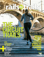
In 2012, RTC
accepted a leadership role in
the Circuit
Trails Coalition
—a 65-member-strong
collaboration of organizations in the
Greater Philadelphia-Camden area work-
ing to create a 750-mile regional trail
system. To date, 300 miles of the network
have been completed, and 50 miles are
currently in development. The 135-mile
Schuylkill River Trail is serving as a major
artery for the system, and new connec-
tions via the recently opened Manayunk
Bridge Trail, developing Copper River
Trail and proposed Merchantville Bike
Path extension have the potential to con-
nect people in the most underserved com-
munities to major employment, education
and cultural centers.
Read more in this
issue’s cover story on p. 12
. Contact: Mary
O’Connor,
mary@railstotrails.org.
n
In the Mid-Atlantic/Baltimore,
Maryland:
Launched in 2015, the
Baltimore Greenway Trails Network
Coalition
represents an unprecedented
opportunity to create an “Emerald
Necklace” for the city of Baltimore. Phase
one includes the creation of a 30-mile-
plus loop of existing trails, inactive rail
lines, parks and protected on-road facili-
ties linking together the Gwynns Falls,
Jones Falls and Herring Run stream val-
leys. A future proposed loop and spoke
network will connect residential neighbor-
hoods, the downtown business district,
former industrial areas, transit hubs, uni-
versities, cultural anchors, stream valleys,
urban coastal wetlands, parks and public
spaces.
Read more in this issue’s Eye On
feature on p. 4
. Contact: Jim Brown, jim@
railstotrails.org.
n
In the Mid-Atlantic/Midwest:
In
2014, RTC joined the leadership team
of the
Industrial Heartland Trails
Coalition
. The vision is to create a
1,450-mile network of trails connecting
48 counties in Ohio, Pennsylvania, West
Virginia and New York. When complete,
it will be the largest destination system in
the country. Approximately 48 percent
of the trail system has been built; major
trails include the 81-mile Ohio & Erie
Canalway Towpath, the 72-mile North
Bend Rail Trail in West Virginia and the
46-mile Montour Trail in Pennsylvania.
RTC is collaborating with municipal
governments, local nonprofits and plan-
ning agencies to create this trail network
that will help to revitalize the rust belt.
Contact: Eric Oberg, eric@railstotrails.
org.
n
In the West:
In June 2014, RTC cre-
ated the
Bay Area Trails Collaborative
, a
coalition comprising more than 40 orga-
nizations working to create and maintain
a world-class regional trail system of more
than 1,000 miles in the San Francisco
Bay Area. At present, roughly 50 to 75
percent of the project is complete. The
network includes several large, regional
systems such as the Bay Area Ridge Trail,
California Coastal Trail, Bay Water Trail
and San Francisco Bay Trail. The latter is
one of the largest in the network, which
will one day traverse more than 500
miles and connects 47 cities. The group
is advocating for increased funding at the
state and regional level and will shortly
release a new report,
Trails Count!
, which
analyzes technologies for counting bicycle
and pedestrian users and makes recom-
mendations to create a regional picture of
trail use in the Bay Area. Contact: Laura
Cohen,
laura@railstotrails.org.
n
In the Midwest:
In October 2014,
RTC helped launch the
Route of the
Badger
, a massive effort to create a 400-
to 500-mile trail network in Southeastern
AARON SCHMIDT
Destination:
America’s Next Top Rail-Trail
BY LAURA STARK
Wisconsin, spanning from Racine to
Milwaukee and west to Madison. RTC
is building a coalition of stakeholders to
implement this shared vision of a fully
integrated system that connects residents
to jobs, shopping centers, educational
institutions and recreation areas, while
also serving as a major bicycling destina-
tion that generates tourism dollars and
new economic development opportuni-
ties. Connections will be made between
very urban and more rural routes such as
the popular Milwaukee-based 13.5-mile
Hank Aaron State Trail, 30-mile Ozaukee
Interurban Trail and 52-mile Glacial
Drumline State Trail. Contact: John
Siegert,
john@railstotrails.org.
n
In Florida:
RTC has worked over
the past several years to establish a trail
network and advocacy alliance in the
Miami region—a project combining state
policy work and local trail development
initiatives. Implemented with talented
and enthusiastic local partners and an
expanding list of funders, the system will
feature many popular trails, including:
the long awaited LudlamTrail; the much
talked about Underline; the ever-evolving
Miami-River Greenway; the Biscayne-
Everglades Greenway (which connects
two national parks); the redevelopment-
oriented Flagler Trail; and many others.
These projects will continue to offer more
active-transportation solutions and sup-
port healthy development in Miami-Dade
county, one of the most culturally diverse
cities in the country. Contact: Ken Bryan,
ken@railstotrails.org.
I
n recognition of this year’s 30th anniversary of Rails-to-Trails
Conservancy, we are conducting a public vote for the 30th
addition to our Rail-Trail Hall of Fame. Inductees into this
prestigious trail group are selected on the basis of such merits as scenic
value, high use, trail and trailside amenities, historical significance,
excellence in management and facility maintenance, and community
connections, as well as geographic distribution. Here’s a list of our
nominees, highlighting what makes each a great trail to visit.
Vote for your favorite in June!
Look for the voting announcement
on our website,
railstotrails.org/30th.
Rio Grande Trail
(Colorado)
The Rio Grande Trail is quintessential
Colorado, featuring a sparkling river,
rustling aspens and scented pines against
a backdrop of towering mountains. Even
better, this bounty of beauty is easily acces-
sible, with several communities dotting the
route and a relatively gentle slope (no more
than 4 percent) running downhill from
the famed ski town of Aspen to Glenwood
Springs. At 42 miles, nearly all paved, it’s
COURTESY RFTA
ANNOUNCEMENT
A new era for trail development
In 2014, in partnership with a team of researchers and 12 U.S. Cities, RTC launched
the three-year Trail Modeling and Assessment Platform (T-MAP) project, which
will create the country’s first national modeling tools to measure trail-system
connectivity, demand and potential impact. The information generated by these
new tools will enable communities to precisely forecast the returns on invest-
ment—related to health and transportation—stimulated by trails, greenways
and active-transportation infrastructure. Contact: Tracy Hadden Loh, tracy@
railstotrails.org. Learn more at
railstotrails.org/TMAP .the longest rail-trail in the state and, if it
wins the competition, would take a proud
place as the first trail from Colorado to
enter the Hall of Fame.
For much of its length, the trail closely
parallels the Roaring Fork River, and ani-
mals can often be spotted along the river-
bank. It’s common to see deer, elk, heron
and bald eagles; you may even spot a black
bear or mountain lion. In winter, the river
valley provides a critical range for deer and
elk, so a small trail section between Basalt
and Carbondale is closed from November
to April; during those months this section
is rerouted to the road.
For a bite to eat, a not-to-miss stop
along the trail is the quirky and lively
Woody Creek Tavern (
woodycreek
tavern.com ), located in the town made
famous for being the residence of the late
American writer Hunter S. Thompson.
History buffs will want to visit the
Glenwood Railroad Museum (
glenwood
railroadmuseum.org ), which showcases
railroad artifacts, old photographs and a
large-scale model railroad. Just a half-mile
from the trail’s western end, the museum
is housed in the Glenwood Springs sta-
tion, built in 1904 and still serving Amtrak
trains.
GETTINGTHERE:
Fly in to Aspen/Pitkin
County Airport (ASE) (Sardy Field), roughly
3 miles fromdowntown Aspen and the
eastern end of the trail. You can also get
there by train; Amtrak makes regular
stops at the Glenwood Springs station
(413 Seventh St.).The Rio Grande Trail can
be accessed from several places along its
route; the Roaring Fork Transportation
Authority (RFTA) website features a
detailedmap with parking locations.
RFTA also provides bus service to several
key communities along the trail: Aspen,
Snowmass Village, Basalt, Carbondale
and Glenwood Springs.Many of these
stops are within a half-mile of the trail.
The buses are equipped with bike racks,
and there’s a surcharge of $2 to take bikes
aboard.
MORE INFO:
rfta.com/trail-informationTo access an extended version of
this article with bike rental info, go
to
railstotrails.org/trailblog.
View from the Walkway Over the Hudson
in New York
rails
to
trails
u
spring/summer.16
26
rails
to
trails
u
spring/summer.16
27
destination
rail-trail report
3
o
years