


 12 / 74

10
STATE OF THE ENVIRONMENT IN THE RAET NATIONAL MARINE PARK (SOUTHERN NORWAY)
and mudflat communities occur. Glacially-formed
bathymetric depressions on the inner shelf can trap
water masses for extended periods such that the
bottom water becomes depleted in dissolved oxygen,
although anoxic bottom-water conditions have not
been found in any locations to date (Dahl et al., 2014).
Biodiversity in hard-bottom communities (macroalgae
and macrofauna) and soft-bottom fauna have
been examined, and nutrients, water quality and
hazardous substances have been studied (Moy
et al., 2015; Green et al., 2010; see also http://
vannmiljo.miljodirektoratet.no).
The
Norwegian
Institute of Marine Research (IMR) holds an extensive
database on Skagerrak (and the Raet Park) coastal
marine life, including a beach-seine time series that
has been conducted annually since 1919, which
samples more than 110 stations along Skagerrak
(e.g. Barceló et al., 2015). Meanwhile, a gill-net time
series from 1984 to the present day (excluding the
1990s) provides a different range of generally bigger
fish and other species (Olsen et al., 2008; Roney et
al., 2016). Norway has an ongoing programme for
mapping marine habitats along Skagerrak, focusing
on eelgrass, kelp forest and fish spawning grounds
(Knutsen et al., 2007; Olsen et al., 2008; Bekkby et
al., 2012; Espeland et al., 2013; Barceló et al., 2015;
Roney et al., 2016).
1.3 Aims and objectives
The aim of this report is to describe the application of
the EE assessment approach to a marine protected
area and to determine the strengths and weaknesses
of this methodology. Its objective is to produce an
environmental assessment of the Raet Park, including
an assessment of knowledge gaps and potential
future environmental risks, for the consideration of
regional management authorities. An analysis of the
EE method will determine its appropriateness for
SOME assessments in a local (subnational) setting.
50
200
100
300
400
500
400
400
50
400
Legend
Raet Nasjonalpark
depth contour (m)
0
5
10
kms
S w
e
d
e
n
N
o
r
r
w
a
y
Arendal
Flødevigen
Tromøy
200
400
300
400
200
100
500
400
400
300
400
100
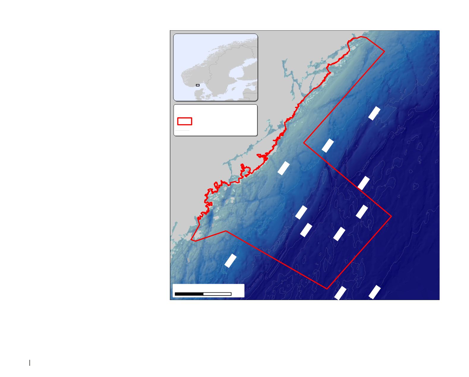
Figure 1:
Map showing the location of the Raet Park in south-eastern Norway. More than 98 per cent of the
park area consists of sea, with some land area and a number of small islands also included. The park extends
up to about 12 nautical miles offshore, with water depths mainly <100 m except for the deeper areas south
of Tromøy, where a maximum depth of up to ~500 metres occurs. The park is representative of deep-water
Norskerenna habitat, as well as a broad spectrum of marine habitats associated with the raet glacial moraine
(Brattegård and Holte, 1995).