


 15 / 74

15
an indigenous traditional way of preserving fish caught
for sale, and also as an important source of fuel wood
(Chong, 1987). The environmental role of this natural
resource includes, coastal barriers in storm protection,
flood and erosion control, and as habitat nursery ground
for fish, shrimps and other marine fauna.
2.4. Structural systems
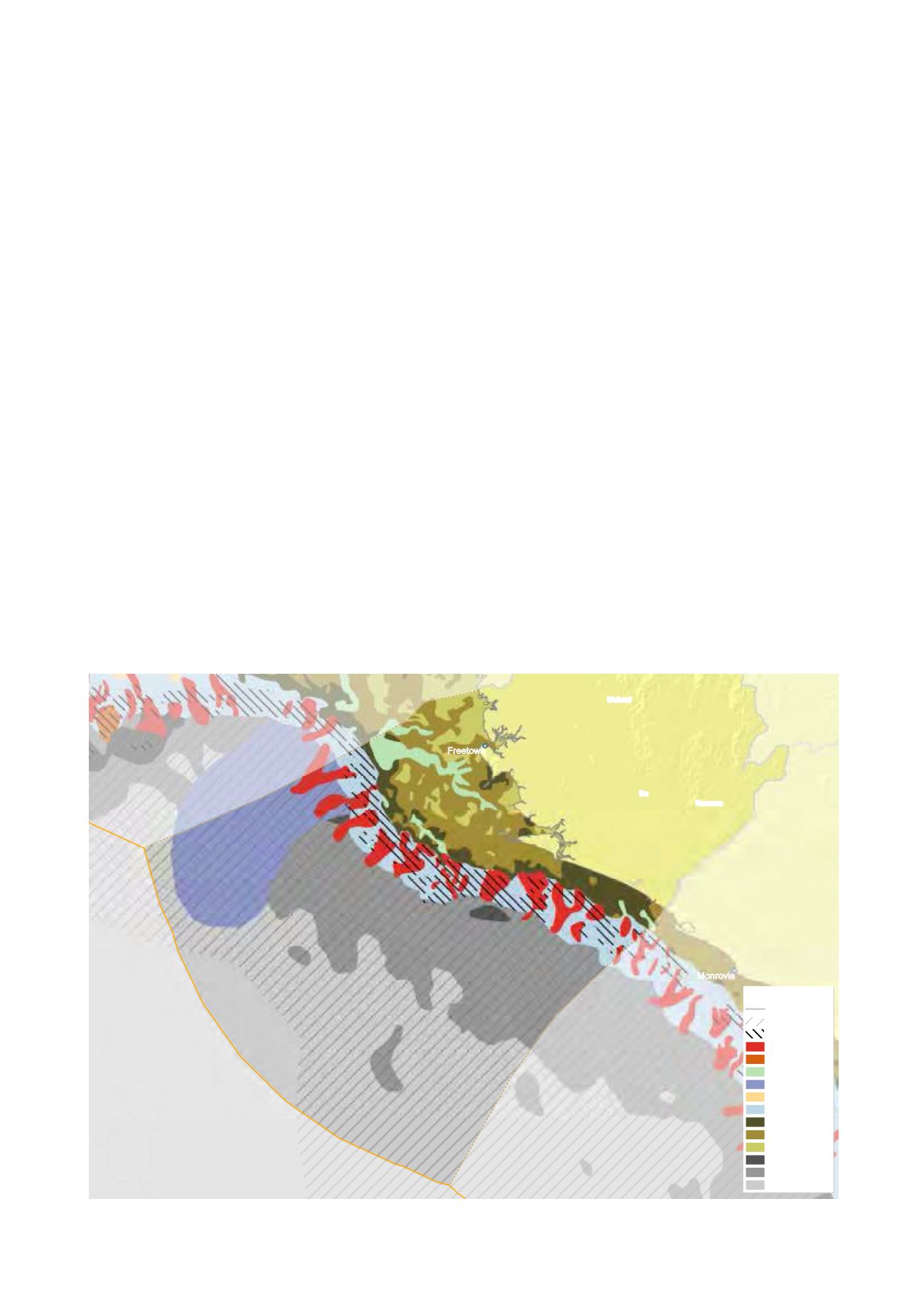
2.4.1. Canyons and Shelf break
According to surveys conducted by a number of
international institutions, the Sierra Leone continental
margin is incised with a number of canyons which serve
as sediment traps (Fig. 2.2). The outer shelf lies below
60–70 meter depth and is smaller in width with greater
angles of inclination of the bottom. In some parts bedrock
is common. This part of the shelf is commonly incised by
the heads of canyons. The state of these canyons is stable.
2.4.2. Seamounts
Seamounts are not characteristic of Sierra Leonean waters.
2.4.3. Large gulfs
Large gulfs are also not characteristic of Sierra Leonean
coastal and marine areas.
2.4.4. Offshore banks, shoals, islands
Amongst the prominent geomorphic features in the
southern part of the shelf are the St. Ann shoals and
the Galinas delta. The St. Ann shoals trends northwest
from Sherbro Island, reaching the outer shelf at the southern
edge of the areas. This shoal is roughly 30 kilometre wide
and rises to depths of 5–14 meter and the surface is marked
by several linear sand ridges oriented northeast southwest
which are 3–5 meter wide and up to 7 meter high.
2.5. Major river deltas/wetlands
The Sierra Leone coastal area can be divided into four main
hydrological areas. These are the Scarcies River, Sierra
Leone River, Sherbro River and the Gallinas and Mano
Rivers basins (Fig. 2.3).
2.5.1. Scarcies River basin
The river is tidal and during the rainy season rises about
2.7m. The wide estuary mouth has mud banks and sand
bars forming Yelibuya and Kortimaw islands. Further
inland, it splits into the Great and Little Scarcies Rivers
which are relatively narrow and lined with mangroves.
2.5.2. Sierra Leone River basin
The main rivers entering this hydrological area are the
Rokel, Port Loko creek and Kumrabai Creek.
2.5.3. Sherbro River basin
Three major river systems, the Taia, Sewa and Wange rivers
enter the Sherbro River Estuary through a complex system
of brackish water channels draining an extensive area
Figure 2.2:
Geomorphology of the Sierra Leone maritime zone
(GRID-Arendal, Harris et al. 2014)
!
(
!
!
(
S i e r r a
i r r
L e o n e
Monrovia
Freetown
Bo
Makeni
Kenema
Legend
country borders
rise
escarpment
canyon
seamount
shelf valley
fan/apron
terrace
Slope
Shelf - high profile
Shelf - medium profile
Shelf - low profile
Abyss - mountains
Abyss - hills
Abyss - plains