


 9 / 64


expanse of open, windswept
prairieland, this is Kansas’s driest and
flattest region. The High Plains were
once carpeted with a lush lawn of
short green grass. Millions of buffalo
(bison) grazed here in great herds.
When white settlers moved in, much
of the prairie was plowed up and the
buffalo were killed off. Today, cattle
graze in their place.
The Smoky Hills region in north-
central Kansas is home to the
Monument Rocks, also called the
Chalk Pyramids. These are a group of
striking chalk formations, sometimes
as tall as 70 feet (21 m) high. They
were created some 80 million years
ago during the Cretaceous Period,
when most of Kansas was covered by a
shallow inland sea. Scientists have dis-
covered extensive fossil deposits in
the chalk beds, including the remains
of extinct species of fish, flying rep-
tiles, and prehistoric birds.
Most of eastern Kansas lies in the
fertile Central Lowlands. Some
600,000 years ago, glaciers covered
this part of the state. Massive sheets
of ice, some as thick as 500 feet (152
m), moved across the landscape from
the north. In the process, rocks and
soil were transported hundreds of
9
Lower Plains: Kansas, Nebraska
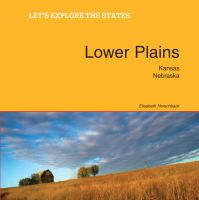
A farm’s windpump on the
Kansas prairie. Since the 19th
century, windpumps have been
used on the Great Plains to
pump water from farm wells for
cattle.