


 11 / 73

7
2
Background
2.0 B
ackground
2.1 Regional Context
The Town of Morrisville is located in northwest Wake County, just south of the boundary
with Durham County (see Figure 2.1 on opposite page). Morrisville is truly the “heart” of
the Triangle Region, which is composed of Raleigh to the east, Durham to the north and
Chapel Hill to the northwest. Research Triangle Park (RTP), home to research, technology
and biotechnology corporate campuses since 1959, is located adjacent to Morrisville’s
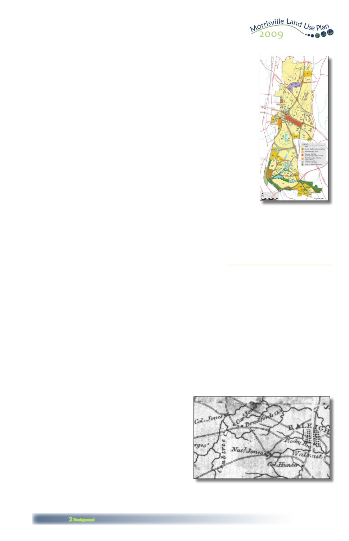
western boundary. RTP covers 7,000 acres (see map to the right) and currently employs
more than 39,000 people in 160 companies. Another regional employment and transpor-
tation hub is the Raleigh-Durham International Airport, located adjacent to Morrisville to
the northeast. The Town of Cary, which surrounds Morrisville’s southern half, has enjoyed
tremendous growth in recent years as it serves as home to many worldwide company
headquarters.
Interstate 40, adjacent to Morrisville, serves as the major east-west corridor for the state of
North Carolina, and the newly constructed NC 540 is in the process of improving traffic cir-
culation around the City of Raleigh. The proposed Triangle Parkway will potentially further
link Morrisville with employment centers in Research Triangle Park. NC 54, which runs north-
south through the center of Morrisville, was the main link between Raleigh and points west
until I-40 was built in the 1980s, and still carries heavy commuter traffic to RTP.
Among the benefits of Morrisville’s location within the region is the fact that Morrisville
residents have easy access to all the best of the Triangle’s amenities. These include Lake
Crabtree and Lake Crabtree County Park, Umstead State Park and the American Tobac-
co Trail. An opportunity exists to link the trails at Lake Crabtree with the American Tobacco
Trail, through Morrisville Town Center, helping to create a truly regional off-road trail system.
Morrisville residents are also located close to major employers in Research Triangle Park,
the City of Durham and the City of Raleigh. Indeed, the success of Morrisville’s business
community has been in part due to the overall economic success of the region and RTP.
Along with the benefits come challenges, one of which is the town’s location adjacent to
Raleigh-Durham International Airport. Noise from the airport restricts land use in the town,
limiting residences, schools and other sensitive uses to the western half of the town. As a
result, Morrisville has experienced a geographic separation between residential and non-
residential uses, which has implications for quality of life (e.g., not being able to walk to
work) and traffic congestion.
An additional planning challenge is the boundary of Morrisville itself. Figure 2.1 shows
the planning jurisdiction boundary of Morrisville as a dotted black line. The planning juris-
diction includes the town limits as well as the town’s Extra Territorial Jurisdiction (ETJ) and
Short-Range Urban Services Area (SRUSA), and comprises the area subject to the policies
included in this plan document. The planning jurisdiction also includes several parcels
annexed by agreement with Durham County. The town limits of Morrisville omit several
areas within the planning jurisdiction, shown as light gray unincorporated areas in the fig-
ure. Since Morrisville is surrounded by adjacent entities, its planning jurisdiction is essentially
fixed at the current ten square miles, with no opportunities for future annexation.
The planning jurisdiction boundary of Morrisville is irregular, essentially surrounding portions
of Cary and RTP on the town’s western side. Some roads meander, crossing into and out
of jurisdictions in their path, such as Davis Drive. This situation is complicated by the overall
growth in the region, which means that communities have become effectively contiguous
in some places with little indication to a casual observer that they have passed from one
jurisdiction to another.
Planning for Morrisville is challenging because each jurisdiction’s planning and develop-
ment actions impact the adjacent municipalities. This plan therefore calls for increased
communication, and joint planning where appropriate, with neighboring jurisdictions.
Through the process of creating this plan, staff and consultants received input from rep-
resentatives of all of the surrounding jurisdictions, plus the North Carolina Department of
Transportation, North Carolina Turnpike Authority, RDU Airport Authority, Triangle Transit,
Capital Area Metropolitan Planning Organization (CAMPO), North Carolina Railroad Com-
pany, and others (see a detailed list and descriptions in Appendix C). By working within
the regional context, while taking action to preserve Morrisville’s history and enhance its
sense of community, Morrisville can more effectively plan for the future.
2.2 Brief History of Land Use and Transportation in Morrisville
The history of a community’s growth and development over time quite
often parallels the historical development of modes of transportation. As
society and technology evolved from a “horse and buggy” age to a rail-
road age, and then to the automobile and air travel eras, they have left
imprints on cities, towns and villages that reflect these same eras.
The Town of Morrisville is no exception, and the evolution of the com-
munity form of Morrisville is closely interwoven with the evolution of trans-
portation technology and its impact on the settlement patterns of the
Town. From its beginnings as a rural crossroads community, to its days as
a railroad stop, to its current expansion reflecting from the twin impacts of
automobile and air travel, the Town’s character and form are intricately
linked to the main eras of transportation change.
During the mid 1700s, early settlers came to Central North Carolina in
search of abundant farmland and to escape the control of England.
Once settled, they found themselves amongst corrupt officials preventing
them from obtaining the rich farmland they came in search of. Violence
erupted between the early settlers, known as “Regulators” and the governing officials
around the area of Alamance County. In 1771, Governor Tryon and his Army set out to the
This map of Research Triangle
Park shows the locations
of its 160 companies.
ExtraTerritorial Jurisdiction (ETJ)
:An ETJ is the area
adjacent to and outside the town limits in which
the municipality has authority to exercise planning,
zoning, building and subdivision regulation.
Short-Range Urban Services Area (SRUSA):
Land that (a)
is projected and intended to be urbanized and served
by municipal services in the next 10 years; and (b)
is not located within a water supply watershed, as
designated by the State. Although the SRUSA is
currently underWake County (rather thanTown)
jurisdiction, the parcels would be annexed to the
town limits or ETJ prior to development requiring
extension of public utilities.
This 1790s Wake County map shows “Col. Jones”
living in the area that would become Morrisville.
Source: Ernest Dollar