


 12 / 73

8
2
Background
area to calm the revolt. Along the way he stopped and set up camp at what is thought
to be the earliest residence in Morrisville, the home of Colonel Tignal Jones along Crabtree
Creek. Gov. Tryon continued to lead his Army to the revolt and nine days later, on May
16, 1771, the Battle of Alamance occurred, one of many events that contributed to the
American Revolutionary War. Wake County was formed as a result of the fighting and an
early Morrisville resident, Col. Jones became one of the earliest leaders for the County.
In the nineteenth century many settlers recognized that the Town known as Morrisville
today was located in a promising area. It was nestled in between the two larger com-
munities of Raleigh and Durham. Major roads began to develop connecting the two
hubs and many settled into the Morrisville area for its convenient location. The future
Chapel Hill Road (NC 54) followed a ridgeline between two watersheds, while the
future Morrisville-Carpenter Road, on the other hand, skirted the higher ground at the
edge of the Crabtree Creek floodplain and crossed Chapel Hill Road at a point where
the Town Center is now located. Until I-40 was built in the 1980s, NC 54 was the main
link between the State’s university in Chapel Hill and the State capital in Raleigh, a key
factor in the development of Morrisville as a center of activity in the region.
Large farms were settled in the Morrisville area, with names like Morris, Allen, Scott,
and Barbee. In the late 1820s, the Shiloh community north of Morrisville was settled
by freeborn African Americans and freed former slaves. The defining moment for
the Town of Morrisville was the construction of the rail line and depot that eventually
connected the coastal areas to Wake County in the mid 1850s. The railroad was part
of a grand civic project to connect Charlotte and Goldsboro through the Piedmont
and spur economic development in the state. The rail line naturally followed the high
ground for ease of construction and closely paralleled Chapel Hill Road. A local resident
and Morrisville’s namesake, Jeremiah Morris, donated several acres to the rail company
for the construction of a rail yard and depot. The rail stop in Morrisville allowed the commu-
nity to trade crops with areas outside Morrisville as well as to obtain goods and materials to
rebuild the community. The skirmish at Morrisville, which occurred near the end of the Civil
War in 1865, caused significant physical damage in the area. The railroad tracks served as
a unifying or centralizing influence on the growth of the rural settlement. By the 1870s Mor-
risville became a popular stop along the rail line due to the growing number of businesses
in the area and its location at the crossroads. The Town of Morrisville incorporated in 1875
with a population of 165 residents.
The rail line continued to be a necessity for the flourishing of Morrisville, but the residents
and businesses also relied on automobile travel through the town. In 1924, the first road in
town, Highway 10, was paved and many businesses grew along the road for the conve-
nience of travelers. The economy had begun to flourish for the town, but the depression
of the 1930’s brought on hardships. The Town’s charter was repealed in 1933 and wasn’t
restored until 1947. For nearly forty years, the Town did not see much change until the cre-
ation of the Research Triangle Park (RTP), an area developed just northwest of Morrisville in
1959. RTP sought to attract high-tech research and development companies such as IBM
and GlaxoSmithKline. Morrisville’s economy improved as businesses supporting RTP com-
panies and the shipping activity through Raleigh-Durham International Airport located in
the town. Major residential development came later, as employees of the research com-
panies moving into RTP made Morrisville their home due to its convenient location. By 2000,
the population of Morrisville had grown to 5,208 and in 2006 the population had more than
doubled to 13,501.
As Morrisville’s commercial and residential neighborhoods filled in over recent years, there
developed a distinct network of local roads tied into the primary roadways. A character-
istic of the local road network is that it is generally composed of short, unconnected seg-
ments – essentially many dead end roads connecting to the major arterials. The railroad
tracks continue to form a barrier to east-west circulation in town and the Crabtree Creek
floodplain forms a north-south barrier. One of the consequences of this pattern
has been to put more traffic pressure on the arterial and collector roadways,
with gradually increasing congestion on some segments and intersections – es-
pecially when combined with the great increase in through traffic from Cary and
surrounding areas.
This trend has also given Morrisville its own distinct urban form in the past decade
or two. Its form is generally one of multiple, broad ‘main streets’ (such as NC 54,
Aviation Parkway, Davis Drive, etc.) interspersed with self-contained residential or
commercial subdivisions that relate to one another only through the main road-
ways. The rail line continues to carry rail cars daily through the town. AMTRAK
operates two passenger lines, the Carolinian and the Piedmont, through Mor-
risville that carry more than 330,000 passengers annually, but there are no stops
in town (Durham and Cary are the closest stations). Though the tracks currently
serve primarily as a freight corridor separating the Town into two halves, there is
a future potential for them to once again exert a centralizing influence on Mor-
risville’s urban form.
Looking at Morrisville’s history in the big picture, there have been three phases: Office and
light industrial growth spurred by RTP, RDU Airport, and Interstate 40; residential develop-
ment for RTP workers and those who want to be in the center of the region; and retail
development to serve the growing residential population. Morrisville is just beginning to
see major redevelopment as vacant land dwindles. The form of the Town has primarily
evolved as a response to the dominant transportation technologies of the time. As Mor-
risville plans for its future land use and transportation patterns, it will be important to both
look at – and look beyond – the current transportation and built infrastructure in order to
establish a vision for the future form and character of the Town.
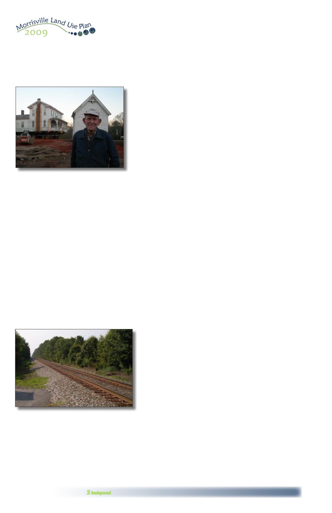
Billy Hartness in front of his former home, the
historic Pugh house built in 1870, being moved
to a new location. Needed road improvements
threatened the structure, so Town staff worked
with Mr. Hartness to find another location.
The railroad through Morrisville today.
2.2 Brief History of Land Use and Transportation in Morrisville, cont’d
Much of this history of Morrisville draws on
the work of Ernest Dollar,
Images of America:
Morrisville
, Arcadia Publishing, 2008.